
Image by Zara Matheson
Richard Florida writes about mega-regions and their economic power:
In earlier research with Timothy Gulden and Charlotta Mellander, we used the satellite images of the globe at night to identify the world’s 40 “mega-regions.” We defined these as a contiguous lighted area with more than one major city or metropolitan region that produced more than $100 billion in economic output.
We found a dozen of these mega-regions in North America – mainly in the United States but spilling over into Canada and Mexico as well. I have written about these mega-regions on Citiesbefore, and I recently completed an updated study of their populations and economies with my colleagues at the Martin Prosperity Institute. I have adapted the results of this newest report forCities readers below, using more current data to identify the populations and economic size of America’s economic powerhouse regions and see how they would compare to the nations of the world.
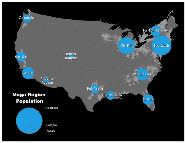
The first map, above, shows the populations of North America’s dozen mega-regions. These mega-regions account for 243 metropolitan areas in the U.S. and Canada, including more than 60 percent of all U.S. metros. These dozen regions have a combined population of more than 230 million people, including 215 million from the United States, or 70 percent of the U.S. population. (So-Cal, Cascadia, and Tor-Buff-Chester include parts of Mexico and Canada).
Bos-Wash is the largest, home to 56.5 million peole. Denver-Boulder is the smallest, with just shy of 5 million. Still, when compared to the world’s largest economies, Denver-Boulder’s economic output would rank among the 50 largest.
Emphasis mine above.
The population numbers and economic output numbers are fascinating, especially as compared to the output of other countries. But I'm bothered by the overall approach and analysis. It strikes me as starting with a conclusion and working backwards to try and justify it.
Clearly, some regions have grown together and essentially become mega-regions. New York City to Philadelphia is only 95 miles, and that's from downtown to downtown. Even though there are stretches of roadway in between that are still rural, they are pretty rare. Similarly, DC to Baltimore is less than 40 miles, and almost entirely developed along the route.
But Chi-Pitts? That's a distance of over 460 miles, and a great deal of it is in fact rural. That "mega-region" also includes Minneapolis, which is 400 miles northwest of Chicago, and nearly all rural west of Milwaukee. Char-lanta also seems to cover half of the southeast, even though again much of that is rural and not urban. It's easy to define these regions by MSA's (metropolitan statistical areas), but anyone who knows anything about MSA's knows that they are drawn very large to begin with. For example, the Phoenix-Mesa-Glendale MSA is over 16,000 square miles. That's nearly the size of several small countries, such as Israel and El Salvador.
Look, I'm a fan of cities and it's important to quantify how important urban areas are to economic productivity. But this type of exercise seems to be one of drawing lines around where most of the people live in the US, giving them arbitrary names and connections (the idea that Minneapolis and Pittsburgh are somehow in the same economic region is just absurd) and putting out some teaser data. Since these regions include very large suburban and exurban areas, I'm honestly not sure what qualitative conclusions are to be drawn from such an exercise.
Oh, and one last item: I'm not sure why Denver & Boulder get their own mega-region, while several others do not. St. Louis and its outlying connections have a similar population and geographic size. The KC-Omaha-Des Moines triangle is easily as legitimate as Tor-Buf-Chester and for some reason big cities such as Salt Lake City and Las Vegas don't even show up. Las Vegas is much closer to LA than Pittsburgh is to Chicago, and arguably more connected economically.
The concept of mega-regions is sexy, especially if you live in one of the few large media markets that actually has many of the characteristics. But a better understanding of the rest of this very large country (and continent) is needed before extrapolating the concept it to fit a conclusion.
If you got value from this post, please consider the following:
- Sign up for my email list
- Like The Messy City Facebook Page
- Follow me on Twitter
- Invite or refer me to come speak
- Check out my urban design services page
- Tell a friend or colleague about this site