

HSR Mapping: Go Big or Go Home
Today, from the Department of Pet Peeves: I’m a map geek, and a fan of passenger rail. So, show me some maps of potential rail systems, and it’s like giving a drunk a free case of his favorite booze. Not a pretty sight.
In the last few years, we’ve witnessed a (much-needed) surge of interest in high-speed rail (HSR) in the US, and a concomitant series of theoretical maps. While I’m a fan of low-speed rail for the reasons I outlined here, it is always fun to take some time to dream.
Here’s the thing, though. If we’re going to dream about HSR, can we at least get the maps right? The maps that have come out thus far bother me in two separate but important ways:
- They are almost universally not ambitious enough to stir the public’s imagination
- They nearly always get the vast middle of the country completely wrong.
In an attempt to be helpful (and provide myself some entertainment), I’ve collected the five most common maps on the internets, and will offer a few comments. I’m especially focused on the non-coastal regions, but you’ll see a few other notes as well. Let’s go from worst to first, in terms of the quality of the maps:
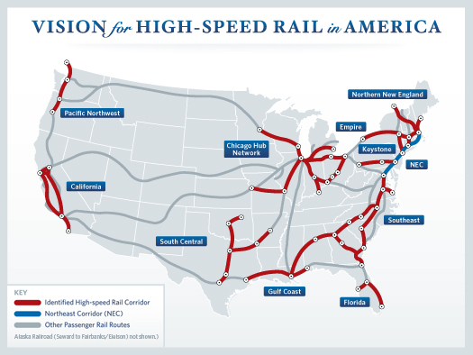
Sadly, the worst map of the bunch comes from the White House. This plan is so completely lacking in ambition that it depresses me to even say much about it. The reality is that this map essentially represents what we have today, with track upgrades to a few key routes. It says nothing about speeds or priorities, and leaves vast swaths of the country with little or no coverage. Imagine if we had undertaken the Interstate system with such a lame approach?
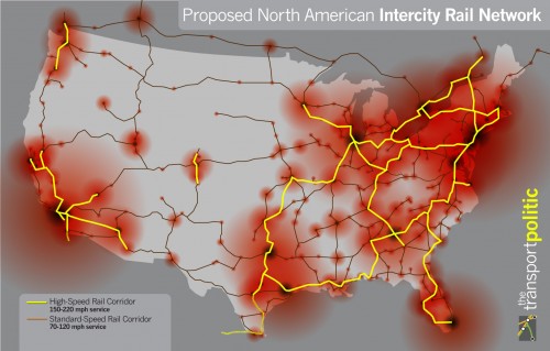
Next up is a more serious effort from the Transport Politic. This map overlays rail corridors with some graphic sense of populated regions, and offers priority of service. The problems, though, are that in terms of the actual service it doesn’t do much better than the White House map. The only north-south corridor in the entire middle of the country winds its way up from Texas through Missouri and up to Chicago. No real connection is proposed between the Great Plains and the Rocky Mountains, nor from Colorado westward. Again, while no doubt an improvement or the dearth of service we have today, it’s hardly a plan that will stir the public to action, or serve large areas of the country well.
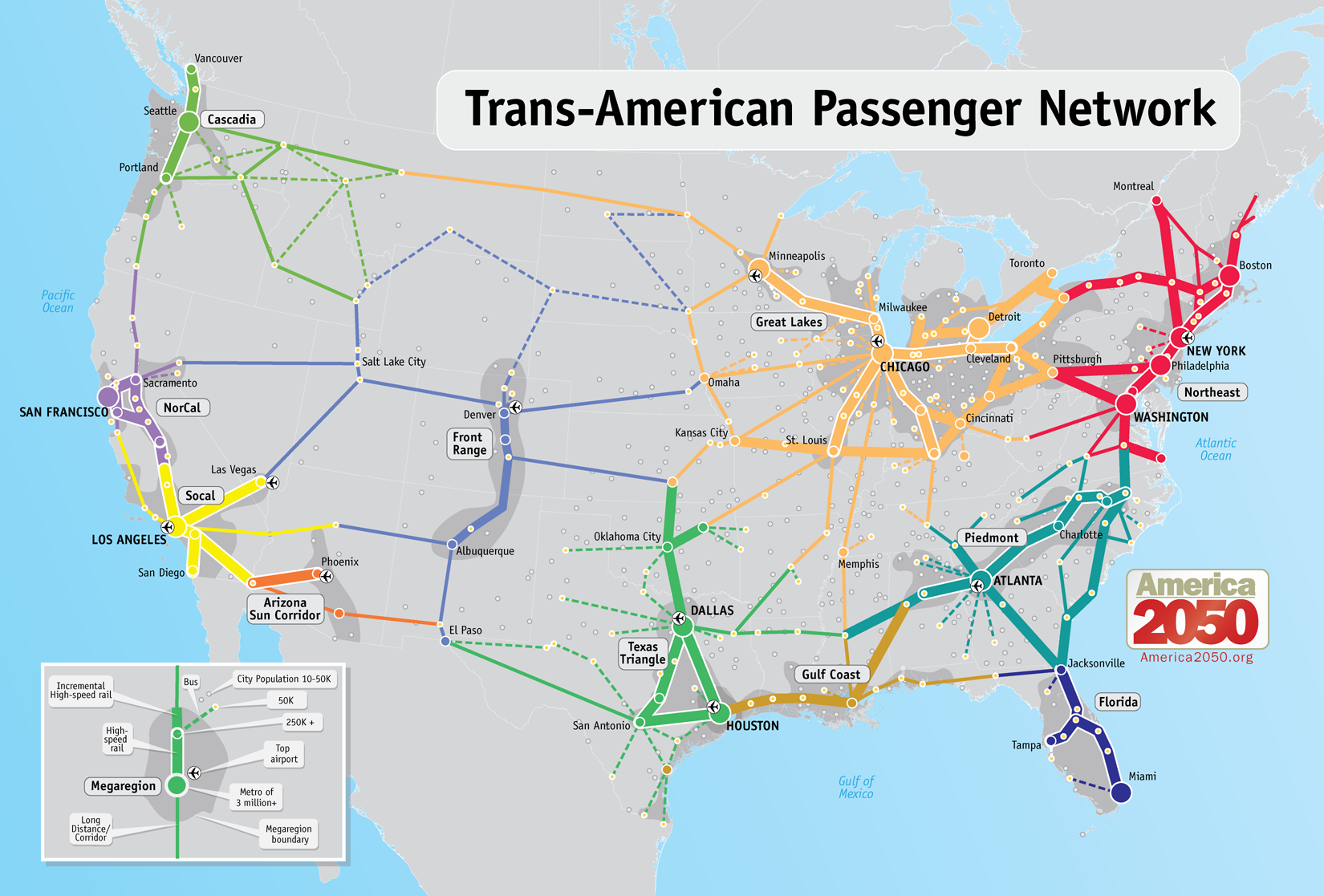
Our 3rd place contestant is a map from America 2050.org. Frankly the only reason that I would rate this map better than Transport Politic’s is because of the graphic quality. It at least makes the system look somewhat interesting and compelling, even while lacking in some key information. For example, a sense of the speed difference between the routes would be very useful.
Even then, this map really makes some bizarre choices on routes. A line from Wichita to Colorado Springs, but none from Kansas City to Denver? Huh? And again, there’s not a single high-speed route designated from north to south in the middle of the country. I have a hat tip to people on the coasts: people do travel north to south (and vice versa) across the country, and not just to/from Texas. Even more strange is the map not showing a continuous West Coast high-speed route, from southern California up through the Pacific Northwest.
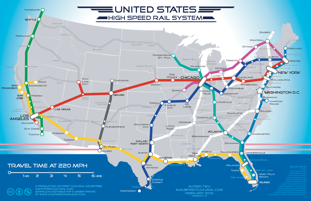
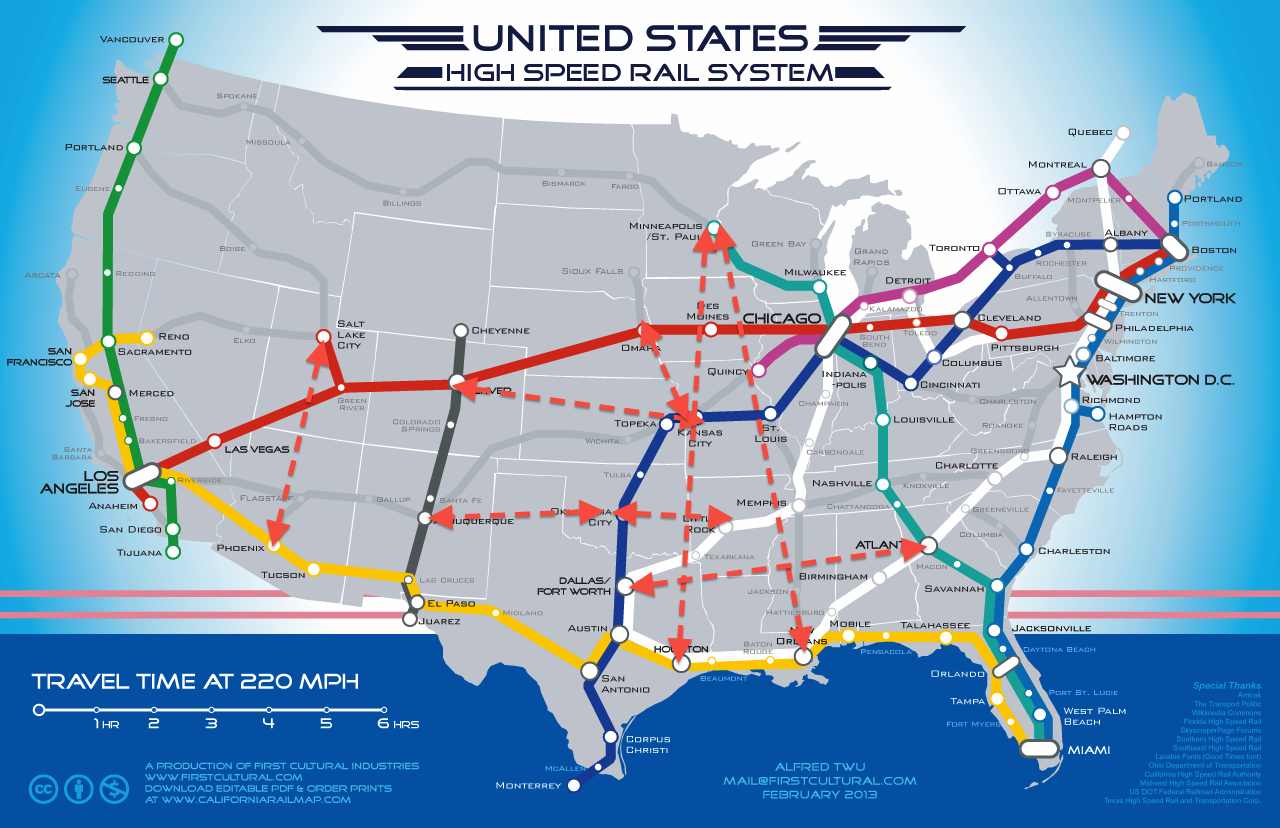
This map by Alfred Twu is the most recent entry, and offers some promise. It’s graphically appealing and simple – the type of map that can stimulate public interest. And, it creates a meaningful “legend” of sorts with the 220 mph designation on distance. Of course it’s a gross simplification, but that’s fine for this kind of map.
Twu’s map does a much better job at covering most of the country than the others, by at least acknowledging a full system of north-south and east-west routes. But it still falls short in the Midwest and West. Again, we still have this same problem of leaving out a route between KC and Denver, east –west routes through Oklahoma, and any sort of logical north-south route through cities in the middle of the country that regularly do business with each other. Also, it’s mystifying why any map-maker of this sort would not have a direct Atlanta-Dallas route. Sure, it’s nearly 800 miles, but that translates to about 4 hours on a train vs. at least 3 flying when travel to airports is considered. For many people in those large metro areas, that is close enough to be competitive. My suggestions for additions to Twu’s map are shown below.
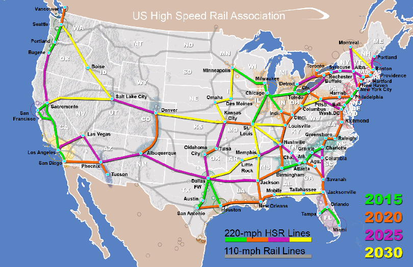
The best of the bunch is the map produced by the US High Speed Rail Association. It’s the most comprehensive, with a very detailed amount of thought given to phasing, routing and speed/technology. A single-color version of the 2030 build-out appears on their website as well. What I like best about this is that is an ambitious plan, very worthy of a first-world country. It gives something to every state in the lower 48, and even provides solid links into Canada. This is the kind of big thinking that we used to have in the U.S.
My issues with the map have to do with some specific route choices, or lack thereof. For this comprehensive of a system, it still misses some north-south connections in the Midwest (in general, north-south routes west of Chicago seem very undervalued), and east-west connections in Oklahoma and Texas. The latter are some of the fastest growing regions of the country, and certainly merit strong consideration for HSR. In the southeast, the choice to go from Atlanta through Athens and Augusta, instead of south through Macon is a little strange. And, the plan essentially bypasses Charleston entirely, though it’s the one of the three largest metro areas in South Carolina.
I fully understand the basic premise that HSR will compete best with air travel on trips between 100 and 500 miles. But that should carry a few caveats:
- How remote are the airports in the origin/destination
- Is the culture in that region used to long trips currently?
- The value of a complete network is more than that of any single route.
It’s not at all hard to imagine that trips of 600-800 miles would be competitive for a great many travelers, given some of the caveats noted above.
More importantly, these maps illustrate the importance of having a big idea, and communicating it clearly. Too many still are very tentative about HSR, and lack the zeal that roadway supporters had in the 20th century. Is it really is supposed to take us until 2050 to build a network that some countries had 25 years ago? 37 more years?
Again, I’m all for a much less-expensive low-speed approach to having passenger rail today. But if we’re going to embrace big ideas such as HSR (which I think we should), let’s actually do it. Go big or go home, as they say.
If you got value from this post, please consider the following:
- Sign up for my email list
- Like The Messy City Facebook Page
- Follow me on Twitter
- Invite or refer me to come speak
- Check out my urban design services page
- Tell a friend or colleague about this site
